Inuit Land Use and Occupancy Project
The Inuit Land Use and Occupancy Project, carried out across the Canadian Arctic over a three year period, 1974-7, is among the most remarkable examples of visionary and collaborative research. Inspired by Inuit leaders and carried through thanks to Inuit in every community, this was the first ever cultural mapping project, establishing a methodology that would be replicated around the world. It came to underpin the creation of Nunavut and settlement of the Inuvialuit land claim.
Extract
The Inuit Land Use And Occupancy Project was the first large-scale cultural mapping project. In the late 1960s and though 1971 - the period during which a new oil and gas exploration frontier was opened up in extensive areas of the Mackenzie Delta - the need for coordinated resistance to large scale industrial development in the north was keenly felt across the communities of the western Arctic. A new organisation, the Committee of Original Peoples Entitlement (COPE), with headquarters in Inuvik, gave voice to local concerns. COPE represented all the regional groups that had strong cultural or economic interests in the region’s land and wildlife - Inuvialuit, Dene, Métis and white trappers joined forces to protest, through COPE, against development activity that appeared to threaten their lands and livelihoods, and which seemed to be saying that the Mackenzie Valley was for the most part uninhabited ‘wilderness.’ COPE saw this apparent invisibility of culture and economic activities as a central challenge. And from 1971, COPE was proposing that maps be made to show, as irrefutable defiance of the apparent blindness of developers and the government agencies that supported or licensed them, the nature and extent of hunting and trapping across the region. Nellie Cournyea, the first President of Cope, took a political lead in this initiative. Peter Usher, the Canadian geographer whose intensive and ground-breaking research into Inuvialuit economic life on Banks Island gave him a very sophisticated understanding of both local and national economic realities in the Mackenzie Delta, worked with COPE on the first conceptualisation and design of this mapping.
Alongside, and very much linked to this new phase of northern industrial development in during the late 1960s and early 1970s, Canada’s modern era of land claims began to take shape. At the same time as industrial development was coming to the north, the oil and gas frontier in the far north was opening up, policies were being implemented aimed at establishing Canadian administration in even the remotest communities. A series of political-legal confrontations between hunters and trappers and developers or government (the two at times being inextricably entwined) shaped the national context. In 1967 an action was brought by the Nisga’a First Nation of northern British Columbia arguing that their Aboriginal Title to their lands and resources had never been extinguished. After losing in the lower courts of British Columbia, the Nisga’a case was taken to the Supreme Court of Canada. Its decision came down in 1973: the Court had split 3:3 on the central question of Aboriginal Title; and it was duly rejected on the deciding vote of the Court’s senior judge. But this result was seen on all sides as a major victory for the Nisga’a, and a powerful blow to the government’s view that all interests would be best served by further and final assimilation of indigenous peoples into Canadian society; Aboriginal Title could not be consigned to legal and political irrelevance. At the same time, the James Bay hydro-electric project in northern Quebec had triggered intense protest and opposition from both the Cree and Inuit whose lands and river systems were going to be drastically inundated or transformed. In 1971 this opposition secured an injunction, halting, albeit very briefly, all work on the project. This in due course led to the James Bay Agreement, negotiated through 1972-4 and signed into law in 1975. This Agreement recognised Cree and Inuit rights to their lands and resources, granted their entitlement to long-term compensation for damage being done to them, and established measures by which there way of life on the land be protected and developed in its own terms.
These challenges to the assimilationist and development directions being taken by government were reinforced by intense concerns about Quebec separatism. In October 1970 activist members of the Front de Libération du Québec kidnapped the province’s Deputy Premier and a British diplomat. Trudeau responded to this challenge by implementing The War Measures Act. In due course the kidnappers released the diplomat, but murdered the Deputy Premier. For Canada, this was a crisis of sovereignty, and Trudeau’s central concern, the refusal to countenance forces that aimed at its fragmentation. Events in Quebec and calls for recognition of Aboriginal title were linked. This build-up of pressures led the government of the day, still led by the charismatic Pierre Trudeau, to announce a remarkable political volte face: having insisted that the entire apparatus of special interests of indigenous people in Canada and the special relationship that these had caused to develop within the Canadian body politic should all be dismantled, Trudeau suddenly declared in 1973, that the whole possibility of new arrangements and, in effect, modern treaties, should after all be “given a try”. To this end the government set up funds and new administrative structures to deal with what came to be called “land claims”. In effect, 70% of Canada’s total land surface was thrown open to some form of negotiation that could result in a new Agreement on Treaty between ‘Canada’ and an Indigenous people or First Nation. With this policy U-turn, Canada appeared to establish itself as a global leader in a new kind of political morality, seemingly centred on respect and acknowledgment for indigenous peoples’ rights to their lands and resources.
It is possible to be cautious about these kinds of accolade or motivation: Canada was concerned to achieve non-conflictual development of its northern resources as well as to establish a new northern equity. The new land claims could be expected to create a stable, low-risk investment environment. Yet the discourse around the new policy, and the initiatives it launched, were striking for a lack of cynicism: Aboriginal people across Canada understood the Trudeau initiative as a recognition of their right to both lands and genuine self-government. Over the following decades, documentation of this right became a central challenge to many indigenous communities in northern and western Canada. Among the first to take on this challenge were the Inuit of what was then called The Northwest Territories; and the decision was made to make Inuit relationships to their lands visible on sets of maps.
A year before the policy change and its establishment of land claims as a feature of federal government policy and institutions, a newly formed organisation, Inuit Tapirisat of Canada, launched the first cultural mapping project. This came to be known as the Inuit Land Use and Occupancy Project (ILUOP). Its ambition was remarkable: at its centre was the aim to make a map biography for every Inuit who had used and occupied the land, and that this should include details of every single form of resource harvesting and related land use. Further, the plan was that older Inuit would make separate complete maps for each of three possible phases of their lives - the time before there was a trading post in their territory, between the arrival of traders and the establishment of a day school in the settlement where they were now living, and the period since the arrival of the school. Younger hunters, trappers and gatherers would make just the one, post school map; but the expectation was that each community, as a whole, would in this way be able to demonstrate not only the nature and extent of land use, but also the ways in which the pattern of use had changed in response to outside forces.
Further, the mapping also aimed to show the nature of Inuit intellectual and cultural relationship to their lands. To this end, separate maps were made to show place names, travel routes, locations of special importance (berry-picking areas, former living and camping sites, graves, areas of special non-economic importance etc); and maps were made to show Inuit understanding of biology - including, for example: caribou migration and calving areas, polar bear denning sites, relationships between killer whales, narwhal and spring ice conditions. The places Inuit had lived in previous generations were marked, as also the house sites of the people who were in their lands before the Inuit - the so-called Tunit or Dorset culture. To amplify these bodies of knowledge, recordings were made of discussions with both Inuit elders and youth in which they shared memories, further details of their relationships to their land and their concerns or fears about the way Inuit life was changing or seemed to be under various kinds of threat.
The results of this vast, ambitious project were published in a three volume report; and various essays have been written reflecting on the way the work was done and what it might have achieved. The ILUOP was very soon followed by cultural mapping work, usually linked to pursuit of land claims or Aboriginal title, that adopted its basic methodology - the map biography and layering of ‘occupancy’ on or alongside ‘use’. This series of projects meant that Inuit in Labrador (Nunatsiaq) and Arctic Quebec (Nunavik) set out their relationships to the North in areas not included in the Northwest Territories. These were followed by methodologically allied mapping projects carried out in Canada by Dene (the western subarctic), Ojibway (northwest Ontario), Danneza (northeast British Columbia); and, in due course by indigenous groups around the world. Some of these projects, including the ILUOP, led to land claims settlements (for example, both the Inuvialuit Settlement Region in 1984 and the establishment in 1999 of Nunavut). All of the mapping projects also played important roles in building social and even psychological strength within communities and families; and in carrying the argument for recognition to centres of power. In each case, they were used to make visible that which had seemed to be, or was deemed to be, invisible.
Those who worked on the ILUOP, spending many hours with Inuit as they set out on maps or in memories the multitude of places they had used and the ways they had used them, were impressed - and, indeed, often deeply moved - by the excitement and joy that this work generated. I remember that in all the four communities where I either helped to create maps or had the job of going over composite maps to show combined areas of use and occupancy, the process had strong social and inter-generational dimensions. As an elder worked on the maps, both other elders who were visiting and members of the family in the house where the work was being done gathered round to watch - and, often, to share thoughts, ask questions, clarify details. Older men and women encouraged the young to be there, to hear the stories; while younger hunters and gatherers became ever more enthusiastic about making their maps.
This was a moment in northern history when relocation to new government built settlements had just taken place. The Canadian government began its policy of creating relatively large, consolidated Inuit settlements in the 1950s. But in the central and eastern Arctic, this change did not take place until the 1960s, and was, in the remotest regions, still taking place in the early 1970s. Many individuals and families were experiencing new forms of stress as a result of the transition from a life centred on a set of hunting camps to life in a consolidated Settlement. Some hunters struggled to get out onto the land as much as they would have liked, with concomitant feelings of despondency and some eruptive anger. Alcohol was beginning to arrive in large quantities, bringing unprecedented levels of stress and even violence. Older Inuit tended to be very critical of the young; and the young often spoke of their frustrations and disappointments. Schools were insisting on routines that did not fit well with previous established patterns of daily life and geographical mobility. Thus the map making was for many people a chance to celebrate their way of using and knowing the land prior to the Settlement era; and the project was a also chance to express deep anxiety about what people saw as new and powerful and, in their view, destructive social and economic forces. These considerations gave distinctive political and psychological energy to the mapping. The process as well as the results can be seen to have many kinds of value.
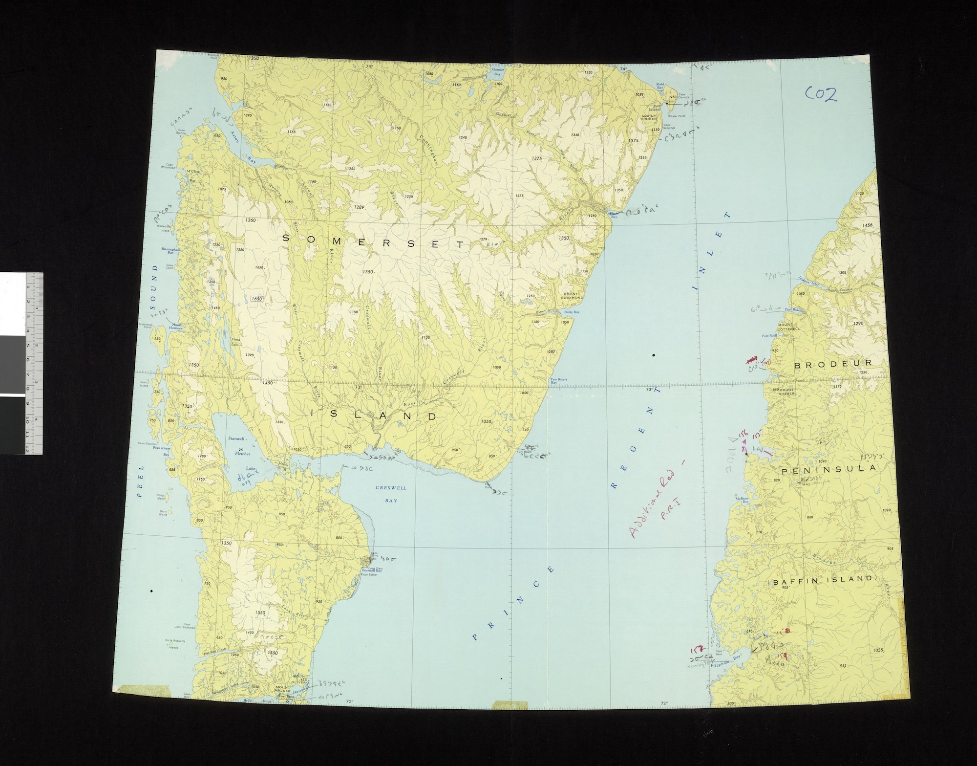
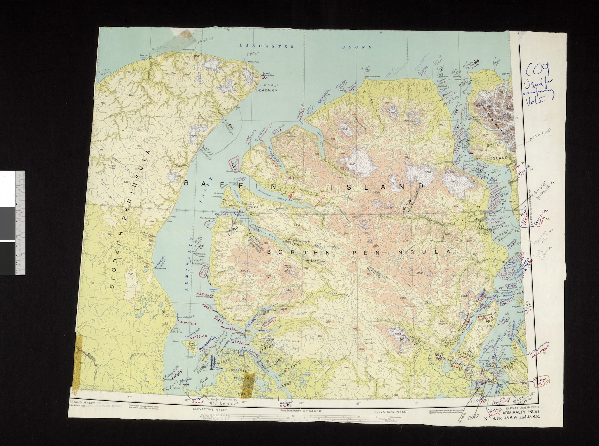
Gallery of Maps
Click on image for enlargement and slide show.