Tracks Across Sand

Notes from Hugh
“We want our story and history to be known and shared in the world.” -‡Khomani San Elder.
The story of the ‡Khomani San of South Africa’s southern Kalahari Desert is one of erasure and reclamation of memory, and of struggle for their ancestral land. A set of projects, spread across 16 years, generated 140 hours of film footage, many hundreds of photographs, sets of maps, GIS (geographic information system) databases, genealogies and language transcripts. In the 16 separate edited films under the title of Tracks Across the Sand, it tells the history of the ‡Khomani through the colonial, apartheid and post-apartheid periods, their dispossession, their land claim in 1999, the re-discovery of their N/uu language, their links to the landscape genealogies, their life today and the challenges they face.
This is a joint project of storytellers from both within the community and from outside. The project began in 1996 about the time the communities of the San of the Southern Kalahari went in search of their roots, their scattered kin and family, and lasted until 2012. Key leaders of the community, notably Una Rooi, Petrus Vaalbooi, Dawid Kruiper Elsie Vaalbooi, Aenkie Kassie and their extended families worked against many difficulties together with a team of which I was just one member - though I came to take on the job of directing the films. Socio-linguist and activist Nigel Crawhall, linguist Levi Namaseb, human rights lawyer Roger Chennells, map maker Bill Kemp, and film editor Haida Paul, along with Betsy Carson as film producer, were instrumental in this process. The project comprises the most extensive documentation of ‡Khomani San heritage, recognition of their story and place in the world that has ever been undertaken. Moreover, it is a foundation for community pride, for the transmission of knowledge and history from older to younger generations of the ‡Khomani San. Also, the UK Charity Open Channels gave invaluable and essential support for some ten years, from the very beginning of the work in the southern Kalahari and through many challenging steps along the way, The films - along with the mapping work and land claims research - owe a large debt of thanks to Sarah Hobson, Sally Morgan and the Open Channels Board. And it was thanks to grants from Comic Relief that our first, crucial projects in the Southern Kalahari were funded and sustained.
About the University of Cape Town (UCT) archive:
The physical archive was handed over to UCT Libraries’ Special Collections in April 2014. Thereafter a digital archive was developed to share this information as widely as possible through an accessible website. The underlying principle has been to make this story or set of stories - up to now an invisible history - visible and accessible to the community, to other similar communities in Africa and the world, as well as to scholars, researchers and human rights activists. The development of the archive today can be seen as a commitment to the original vision and dream of the San of the southern Kalahari, expressed with great energy and resolve in the 1990s. Elders and leaders of the ‡Khomani San expressed the wish that their history and their place in the world should be known and understood. They had lived through generations of discrimination, invisibility, denial of their rights and displacement from their lands. The body of work generated by the land claim established documents which also helped them to win the land claim that helped to re-establish the scattered communities of the people of the southern Kalahari. The stories they told, the films they helped make, the maps they drew, and the languages they wished to defend and celebrate give voice to their heritage and memory, now secured within this archive for future generations. In some instances we are still seeking information, and community participants are encouraged to please help us complete these records as accurately as possible.
Additional Notes
In 1996, when the ‡Khomani San land claim was first launched, there had been a long period of drought across the southern Kalahari. Not a drop of surface water was to be seen along the full length of either of the sand-filled river beds of the Auob and Nossop, the two rivers that run through the land where South Africa meets Botswana and Namibia, Some said that this lack of rain was nothing to do with the narrowly meteorological: if the Bushmen were not living on the land and carrying out their ritual life, if they were not making their dances and songs, then the rains would not be summoned. Drought, they said, resulted from the dispossession and expulsion of the people from their lands. On March 21st, 1999, when the #Khomani San Land Claim Agreement was being signed at Molopo, a dark cloud loomed across the sky and rain began to fall. It continued to rain for many days; the two rivers flowed; the southern Kalahari exploded into life. Ten years after the claim, sitting in the dunes, near his new grass house close to the San gate to the Park, Dawid Kruiper, official leader of the ‡Khomani San remembered the day the deal had been signed:
Mbeki came with the helicopter and the black car… When the helicopter landed there are lovely loose little clouds. Here a cloud, there a cloud, another one, lush clouds. And the clouds begin to speak… And from the top, a faint rain already came. When the rain began to fall hard, the helicopters rose. Within two days, there were pools of water between the dunes. After thirty dry years, on that specific day, it rained. Since that time, the veldt looks like this (pointing to the abundant grasses around him). Those years when we were forced out were sad. Then the land was given back, signed for. All those bad things they did to us, we forgave them. That is why the blessings of rains came that day…So that we can eat such fat meat today.
In October 1997 Dawid Kruiper, Anna Swartz and Jakob Malgas, along with members of their families, gathered at the Red House at the edge of the community of Welkom, a few miles from the gates to what was then called the Kalahari Gemsbok National Park. A small team of researchers joined them, to begin work on documenting the #Khomani San relationship to their lands and to put together the events, the mixture of personal and public narratives, that had caused them to move from homes inside the Park to life at the margins of a remote Township and shelters at the side of the road. They identified themselves as ‘Bushmen’, though had begun to use the term ‘San’, linking themselves to a web of hunter-gatherer societies across the region, and to claims to ancestral territories and heritage at the very north of the Cape.
Welkom was a sprawl of small homes, occupied by families who had been classified as ‘Coloured’. There was a school, Church, store and a municipal building. The main sources of employment in that desert landscape were neighbouring sheep farms and the various tourist and management facilities within the Park. There was employment, but this was at the lowest levels of earning or security; there was much poverty. The Bushman families, many of whom had not accepted classification within the Apartheid system, had put up a scatter of shacks and grass huts on an area at the northern side of Welkom, where they were accepted as squatters with rights to neither lands nor any official local employment. They lived there from hand to mouth, selling crafts and some artwork to passing tourists, posing to have their photographs taken alongside their roadside grass huts, wearing ‘traditional’ Bushman clothing.
In the years before the research began, members of the Kruiper and Malgas families had worked for a few weeks at stretch at the tourist resort of Kagga Kamma, where, a three hour drive away from Cape Town, near the Cederberg Mountains, they had been a living exhibit of Bushman life. But in 1996 this had ceased.
This group, led by David Kruiper and supported by the lawyer Roger Chennells, had taken advantage of the new legislation that the ANC had introduced soon after coming to power: those dispossessed since 1913 by racist laws and administrative measures could seek redress through newly created Land Claims Courts. Dawid Kruiper and his father Regopstan, then living in or near Welkom, had told Roger about their expulsion from their homes inside the Park. If this account could be documented and admitted by the Courts, then the Bushman families at Welkom, all of whose stories appeared to take them back to a life in the Park, could seek a return to them of those lands, or due compensation for all they had lost. This became the ‡Khomani San Land Claim. A new and very small NGO, the South Africa San Institute (SASI) was created, with Nigel Crawhall, the socio-linguist then based in Cape Town, its first Director. Nigel invited me to work with SASI on developing then implementing a series of research projects that would provide the background data and narratives that any such claim would have to rely on.
Thus it was that Nigel and I, along with the distinguished and brilliant linguist Professor Tony Traill, squatted on the sand under the roof of the Red House, and laid out a set of maps that showed the detail of the lands of the southern Kalahari. The Red House itself had been built as a result of filing the claim - this was to be the headquarters for those who were leading the process, serving as both a place to gather, hold meetings, gather round a central fire to share food, stories and the energy of the possibilities for the most marginal of people in the new South Africa. This work was part of a complex of developments, including a recovery of identity, self-esteem and collective knowledge. Here were people able, perhaps for the first time in their lives, to share and celebrate the details of their expertise and history. The optimism and energy were palpable. There was both intense engagement with the process and a warm, welcoming humour. Seriousness of purpose and laughter.
The work with the maps began with place names. Dawid and Jakob knelt side by side on one side of the map sheet; Nigel, Tony and I on the other. Cait Andrews, who had for some years been working and staying with the Kruiper family, was there as interpreter from English to Afrikaans - the language of the workplace and everyday life in Welkom. We had no one to help us with the Khoikhoiguap, the Nama that was for many of the Welkom San their first and preferred language. And the place names that they recorded first were in Nama. I remember the excitement when Tony Traill wrote out their name for Twee Rivieren, the place where the !Aob and Nossop - the two rivers running south through the Park - met and joined. This was the place where the gates to the Park had been built and where it had set up headquarters and tourist lodges. It was also where the Kruipers and others had often lived or gathered. Tony went over the sounds, making sure he got the clicks right, and then wrote it onto the map. ‡aka‡nous. In this one word, at this moment of writing, the people of the southern Kalahari affirmed their way of knowing the place in a form that outsiders would be able to read and therefore acknowledge. It was a first step on the journey towards the complex of information and stories that were to become an immense body of research findings; and the intellectual underpinning of what was to become the Claim.
The mapping had taken its inspiration from the work done in the 1970s with Inuit and First Nations in northern Canada. The core idea of those projects centred on each person making a map of all the different ways in which they had used and knew the land. Areas where they had hunted and trapped at different seasons; places where they went to find berries and roots for both food and medicine; favoured camping and dwelling locations; travel routes; the places where ancestors were buried along with feature of their lands that had special cultural or historical importance for them; and details of their descriptions and analysis of zoology and ecology. This generated many kinds of maps, with varying degrees of detail and specificity. Combined as a set of set of information about the way a group of people situated themselves in their landscapes and how they made use of their resources, this work put in place a compelling statement of claim to territory, and a strong rejection of any suggestion - coming from settlers, government or industrial developers - that the land and its many forms of life where some kind of frontier, some version of terra incognita, available for occupation or exploitation by others.
As it turned out, the making of these kinds of maps in the southern Kalahari was not as comprehensive as we had hoped. Some of the men and women at Welkom were well able to create the information that had been generated so effectively in northern Canada. But many of those we worked with had been displaced from their lands and disconnected from their heritage for at least a generation. They had not grown up on those lands, and had spent most of their working lives working on the farms, often as sheep herders, that had been created through the lands north of the Orange River, and reaching up to the very edge of the Park. Instead of the more conventional land use maps, many of these men and women wanted to show where and how they had lived on and near those farms. And, as they created these timelines, speaking of the events, conditions and challenges of their lives as farm workers or, in some cases, squatters at the sides of roads, they described the many ways in which their heritage had nonetheless been of immense and indeed vital importance to them. Short of many of life’s essentials, from food to medicines, they harvested all the edible and medicinal plants they could; and, if it was at all possible, hunted, often in fear of being detected and punished, for whatever game they could harvest. In this way, San intellectual heritage sustained families even in their displacement and dispossession. Bill Kemp, who had played a key role in the Canadian Arctic mapping, worked with Nigel and the elders, to create a set of map-posters that set out for separate families this blend of migrant labour and distinctive intangible culture.
As we began the mapping and timeline work, questions arose about the languages that the people were using. As already mentioned, many of the San at Welkom spoke Afrikaans and Nama. These had come from their long connections with Boer farmers for whom so many San families had worked, and the Nama sheep herders, with whom the San of that region had developed a complex inter-dependency and inter-marriage. The San language appeared to have disappeared. Dawid and Jakob told us that their grandparents had spoken it; but it had not been passed on to their generation. In fact, the San language of the southern Kalahari had been declared extinct in 1974, when Tony Traill had visited the region in order to establish if there were still any speakers of what was supposed to have been an original ‡Khomani San language. In the wake of its linguistic neighbour to the South, /Xam, the language appeared to have died out. Then we met Elsie Vaalboi, who turned out to be a fluent speaker of what she referred to as ‘die Outaal’, the old language. Elsie, mother of Pietrus Vaalboi, who had been working with Nigel and SASI on the land claim, was living in Rietfontein, a small, mostly Nama community right on the Namibia border. Tony Traill returned to the northern Cape, spent time with Elsie at her home, and confirmed that she spoke the language that he had thought was extinct. Thus the San language of the area, N/uu, became an element in the claim.
Elsie believed that there were no other speakers of N/uu still alive. But after spending time visiting townships and farms wherever people who identified as San were said to be living, Nigel and his team found twenty-two other speakers. This led to the mapping of their lives; and to the discovery that there were displacements of families from the National Park in the 1930s, as well as from outside the Park, where farmers had taken over the land between the Orange River and Twii Revieren. Then we learned that some Mier families, Nama and Bastaar who had been farming deep within the area turned into the Park, also had been forced out of their lands and homes. Thus the ‡Khomani San Land Claim came to include different strands of history, heritage and loss. This widening of the claim was not without its difficulties; rivalries and tensions began to develop; lines of difference and suspicion started to be drawn between the original claimants, based at Welkom, and the families of N/uu speakers who were living in townships in or near Upington. Although genealogical work showed kinship ties, and many individuals from different sides of these apparent divides were delighted to establish or re-establish shared interests of many kinds, a tendency arose among some outsiders, including well-meaning NGOs, to speak of the claimants as if some had a more authentic claim than others. In fact, all shared the same foundation for a claim - they had been displaced and dispossessed by racism since 1913. And the Claim relied on the evidence from all sides of the region's history, from each narrative of loss. In due course, the Claim did indeed apply equally to all segments of the region’s San who shared histories of dispossession; but the divisions were cut painfully deep and have been slow to fade.
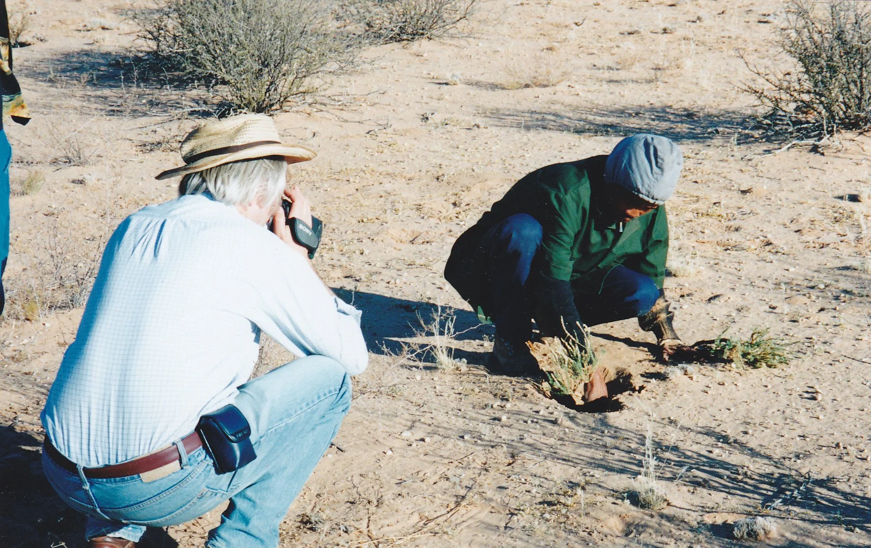
From the beginning of the work on mapping, oral history, time Iines and languages, we filmed as much as possible of the process. On the first visit to Elsie Vaalboi, and then meeting with Aenki Kassie at Rosedale, we had with us a basic video camera; we had this with us when Aenki took us to meet /Una, Kabakas and Keis, the three sisters at Swatzkop. And we filmed a series of meetings and discussions at Welkom. Thus it was that the project included, from almost its very start, film. And we learned, fast and sure, that filming contributed in profound and crucial ways to the work. Oral culture is performance; stories are told for others to watch as well as listen. The camera can give added respect and recognition.
For many whose narratives became the core of the southern Kalahari land claim, this process gave them an opportunity, perhaps for the first time in very many years, to be heard, to be given recognition for who they were and the place they occupied in the region and, indeed, within South Africa. So the camera was a research tool. We did not think, and did not film with an idea of making any final film. It added to the work, and never defined it. In due course, we were able to buy a digital camera; and then, in 1999, we had the great benefit of a British professional cameraman, Jonathan Bloom offering to help with the project. This was followed by more such help, this time from the Canadian cinematographer Kirk Tougas, in 2008.
At each step, on each journey into history, out onto the dunes, gathering stories or data, memories and genealogies, we filmed what happened, what we saw and as much as possible of what we heard. The land claim went through, of course, in 1999; but the work on maps, oral history and language continued long after. Intensive work was done in 2000, 2001 and 2002. In 2008 I returned to the region and talked (and filmed) with many of those who had lived through the claim and its aftermath. This led to another whole level of data, a further set of narratives, which all spoke to the way the claim had affected people’s lives - often in complex and difficult ways. In 2010 we went again to meet with those we had been working with over the preceding fourteen years, and filmed some more conversations and reflections.
Thus the film material came to constitute a heart of the results of the work. From 2010 - 2012 Haida Paul, the Vancouver based editor whom I had made several films with, offered to begin editing this vast body of visual material. This further stage of the work resulted in the DVD, Tracks Across Sand, with its sixteen edited pieces. In the year following its completion, the DVD was shared and sections screened to groups and audiences across the region and far beyond. Families in Welkom, Twee Rivieren and other northern Cape communities watched their story being told by their own people in their own world. And many audiences, all kinds of audience watched it in Kimberley, Upington, across the northern Cape; as also in Cape Town and Johannesburg. It was distributed to villages across Africa - over 200 copies were sent to people who were thought to share the kind of history and challenges that the people of the southern Kalahari had faced. It has also been seen and discussed in many centres across the world, from England to Canada.
But this turned out not to be the last stage - there has followed the consolidation and securing of all the results of the research, recording, map making and filming, the whole body of material, as an archive at UCT. Work on this archive continues; some of the earliest recordings are being revisited to ensure that translations and metadata, background and related information that can cast light on what these materials represent and mean, are added. The aim is to include the results of all this recent and ongoing work is included in the archive, and especially within its presence on-line.
When David Kruiper spoke to us about the signing ceremony, and remembered the way the clouds appeared, he was evoking optimism and a spirit of reconciliation. The great challenge, in the southern Kalahari, as for all peoples who have been displaced and dispossessed by colonial forces, for the many communities that struggle with the aftermath of racism and in the grim challenges of rural poverty, is to see the way to sustain reconciliation and realise optimism. It has not been easy; and hard questions have been asked about the process and its outcome. The overall results will take many years to reveal themselves, and all kinds of commitment, support and wisdom will be needed to meet with the hopes heard coming from those voices in the sky in March 1999. It is to be hoped, and more than hoped, that the existence and sustaining of the archive will contribute to the needs and aspirations of the ‡Khomani San. As Nigel Crawhall said when we were coming close to the end of the work, it is far easier to achieve justice than to secure wellbeing. But in so far as wellbeing depends on being heard, recognised and respected, and to the extent that the experiences and knowledge of the people of the southern Kalahari are known and understood, the materials in the archive, and the continuing use of the archive by the San and others around the world, can help to ensure that the ‡ Khomani San, along with their neighbours, are given rightful place in the rainbow of the new South Africa.
All of those who speak for themselves and their families in these materials, whose voices and lives are part of the archive, along with all of us who had the privilege to work on the mapping, recording and filming, must give our thanks to UCT for creating the archive and for ensuring that it is accessible on line. We look forward to working with UCT, and the dedicated staff in the Archives and Library, to carry all this forwards into the future.
Acknowledgements
The process of producing Tracks Across Sand and the development of the archive was made possible by the assistance of the following donors and organisations:
Open Channels, South African San Institute (SASI), Comic Relief Inc. UK, University of Fraser Valley, Special Collections, UCT Libraries.
Documents
Tracks Across Sand Gallery PDF →
Tracks Across Sand Megan Biesele Review PDF →
Tracks Across Sand the Film’s Story PDF →
'Rediscovering N/uu, the language of the southern Kalahari PDF→
Synopsis
In sixteen chapters containing four and a half hours of materials, Tracks Across Sand offers a unique chance to travel to the edge of the Kalahari, to a struggle for indigenous rights, and into the heart of contemporary South Africa. Driven from their lands, forced into a life of destitution, and denied the right even to speak their own languages, the ‡Khomani San fight for their heritage.
Culled from over 130 hours of video recorded between 1996 and 2010, Tracks presents a unique record of the ‡Khomani San, bringing together the story of Africa's first Bushman claim, from preparation through to ten years after the claim was granted. Seen through the eyes and told in the words of the ‡Khomani San themselves, this film chronicles the struggle for indigenous rights by a people who are defying a history that has attempted and failed to make them disappear.
The contents of this interactive DVD set include not only the extraordinary video shot over the course of the project, but archival photos, maps, family trees, stories, segments on Bushman language, and interviews with people outside of the San community who were instrumental in the claim and community building. As an added attraction, the disk also holds a photo gallery of the film's participants which can be downloaded and shared within San communities.
The ‡Khomani San of South Africa speak for themselves; and they also speak for the many, many people like them, who are struggling to have their voices heard and their human rights recognized. Tracks Across Sand is above all a record of a remarkable time and remarkable people — and may be the only record anywhere in the world of a land claim over such a span of time, from dream to retrospect ten years after settlement.
Published 2012. 270 minutes
Where to find this film:
DVD available on Face to Face Media
Credits
Camera
Kirk Tougas
Jonathan Bloom
Hugh Brody
Editor
Haida Paul
Producer
Betsy Carson
Director
Hugh Brody
THIS PROJECT WAS MADE POSSIBLE BY
COMIC RELIEF / University of the Fraser Valley / OPEN CHANNELS
AND
The South African San Institute
VERY SPECIAL THANKS TO:
Nigel Crawhall
Roger Chennells
Levi Namaseb
Bill Kemp
Nanette Fleming
Ted Chamberlin
Sally Morgan
Annetta Bok
Anna Van Esch
Nama and N/uu Translations
Levi Namaseb
Afrikaans Translation
coordinated by Louie Ettling
Translators
Louie Ettling
Vanoula Steinberg
Abel Pienaar – SA coordinator
Francois Loots
Van Heerden Heunis
Manie Fourie
Christell Stander
Andre Roothman
Dawid Minnaar
Marie Human
Additional Editing
Tomo Brody
Online Editor
Larry Di Stefano, Caleb Bouchard
Graphics
Mark Stuckert
Sound Editor/mixer
Miguel Nunes, Bionic Audio
Facilities
The Sequence Group
Maps
Strata360 / Bill Kemp
Sequence
Stills
Archives –
University of Cape Town – Rare Books Division
University of the Witwatersrand – Rare Books and Manuscripts
Bill Kemp / Strata360
Nigel Crawhall
Topical Press Agency / Hulton Archive / Getty Images
The Bain Family
With additional support from:
Lucy Hooberman, Brad Whittaker, Yvon Dandurand, Lizelle Kleynhans, Valter Blasevic, Belinda Kruiper, Eleanor McGregor
And
Jo Maurice: Project Officer, Film and Television Department, British Council, London
Les Philipps: Regional Director, British Council Southern Africa
Fred Mulder: The Network for Social Change
Kate and Robert Gavron: Robert Gavron Charitable Trust
Dennis Goldberg: Community Health and Reconstruction Training (Community H.E.A.R.T)
Gallery
Click to enlarge